3D Design Landscape Software Compared for 2026
Compare 3D design landscape software by modeling, plant libraries, rendering speed, pricing and exports. Find the right tool for your workflow.
A client is reviewing a garden proposal on a laptop. The 2D plan is accurate, but nobody can tell whether the planting beds feel too dense, whether the retaining wall dominates the patio, or how the space will read from the kitchen. You have one meeting to resolve those questions. If every revision requires a long desktop render or a rebuild in another application, approval slows before the design has a fair chance.
That's the practical reason to evaluate 3D design software around decision speed and client communication, not just feature lists. Terrain tools, plant libraries, real-time walkthroughs, CAD exports, and AI concept generation solve different jobs. The right choice depends on whether you're selling a direction, documenting construction, coordinating a public site, or testing several planting and material options quickly.
Table of Contents
- Introduction Why Landscape Visualization Decides Projects Faster
- What 3D Design Landscape Software Actually Covers
- How Leading Tools Compare on Core Landscape Criteria
- Pricing Render Speed and the Real Cost of Iteration
- Choosing the Right Tool for Your Project and Team
- Fast Concept Generation Where AI Fits Without Replacing CAD
- Frequently Asked Questions About 3D Design Landscape Software
Introduction Why Landscape Visualization Decides Projects Faster
Design approval is often visual before it's technical. Clients may not read contours, planting symbols, or material hatches with the same confidence as a designer. They can, however, react to a patio that feels cramped, a tree canopy that blocks a view, or a lighting scheme that changes the character of a terrace.
A useful workflow turns those reactions into decisions during the meeting. A designer can show a measured layout for accuracy, then switch to a rendered view for atmosphere and scale. That combination reduces the gap between what the plan says and what the client thinks they're buying.
The distinction matters because not every tool is built for the same conversation:
- CAD platforms prioritize precision, layers, dimensions, documentation, and coordination.
- Real-time visualization engines prioritize interactive walkthroughs, material changes, vegetation density, and presentation quality.
- General 3D modelers offer flexible geometry, but outdoor design-specific workflows often require extensions, libraries, and manual setup.
- AI concept tools prioritize rapid visual exploration from a photo, sketch, or plan, but they aren't substitutes for measured construction documents.
The most effective stack often uses more than one category. An AI-generated concept can help a homeowner choose between a formal garden and a low-maintenance planting direction. A CAD or specialist 3D platform can then establish grades, dimensions, drainage intent, and buildable details.
Plant libraries also deserve more attention than a generic object catalog. A convincing proposal needs species that read correctly at different scales, mature canopy proportions, seasonal variation, hardscape textures, and believable relationships between planting and architecture. A beautiful render with inaccurate vegetation can create approval problems later.
For a practical starting point on communicating early design ideas, see this guide to landscape design concepts. The useful question isn't “Which software wins?” It's “Which bottleneck is costing this project time right now?”
What 3D Design Landscape Software Actually Covers
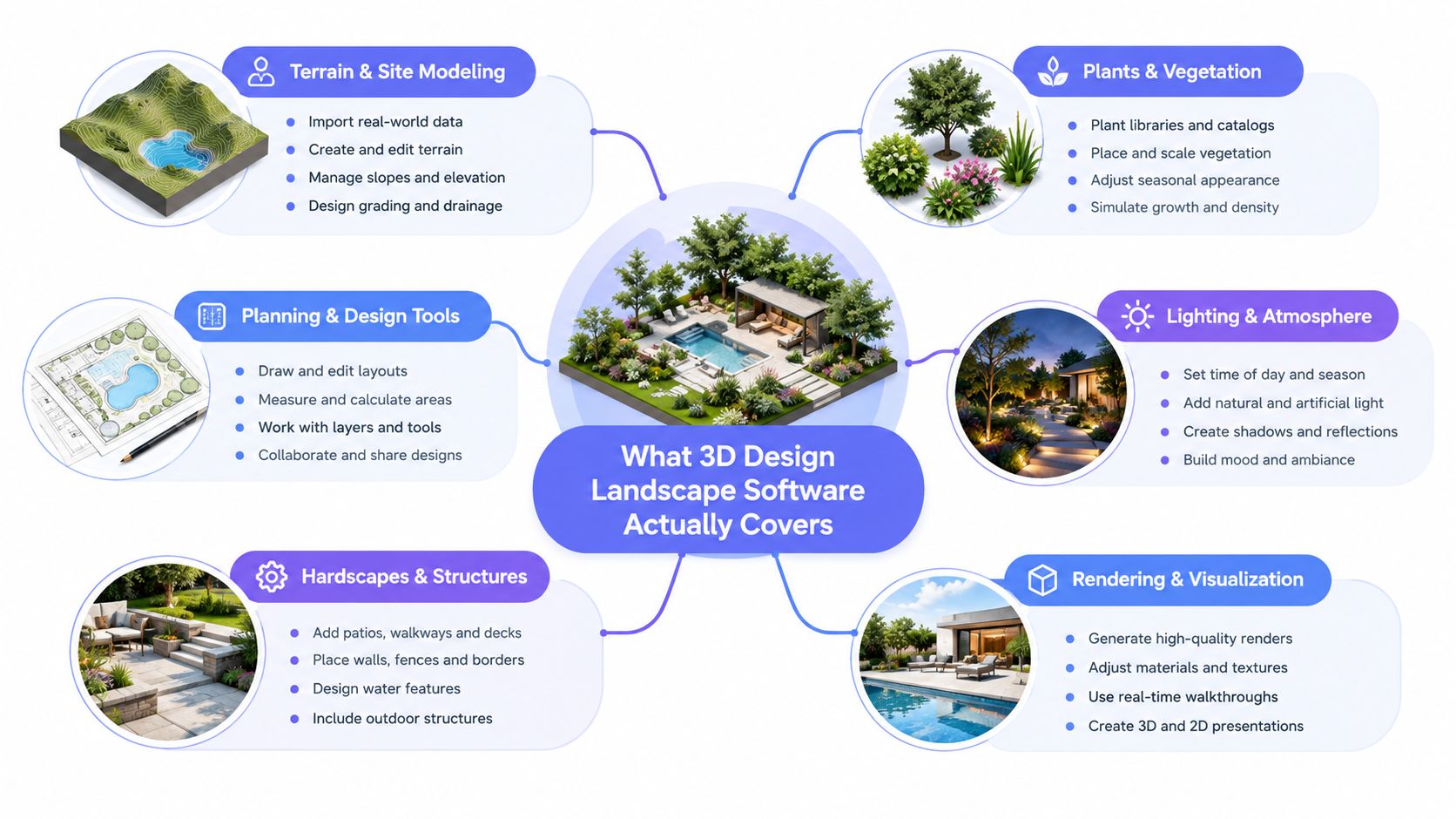
The category combines several jobs that are frequently sold under one label. Terrain and hardscape modeling handles slopes, berms, retaining walls, steps, decks, pools, paths, patios, and site structures. Planting systems add trees, shrubs, perennials, turf, ground cover, and seasonal or growth-related representations.
A third job is visual communication. Real-time engines let teams move through a proposal, change materials, compare lighting, and explain spatial relationships without waiting for a separate render. AI tools approach the same communication problem from another direction, generating a concept from a site photo, marked-up sketch, or clean plan.
The fourth job is technical exchange. Depending on the platform, teams may need scaled drawings, CAD compatibility, schedules, material takeoffs, site context, presentation exports, or files that can continue into architectural and engineering workflows. A tool that produces attractive images but cannot support the next handoff may be useful for sales, but not sufficient for delivery.
Why the category keeps expanding
The commercial base is already substantial. The 3D design software market was estimated at USD 7.75 billion in 2024 and USD 8.29 billion in 2025, with a projection of USD 15.13 billion by 2034 at a 6.91% CAGR, according to Market Research Future's landscape software market analysis. The same source also places the 3D design segment at USD 1.8 billion in 2023.
That market context matters because outdoor planning is no longer a narrow drafting task. Architects, designers, contractors, developers, and client-facing teams all need faster ways to review a site before committing to detailed work.
Adjacent visualization demand is moving in the same direction. Architectural visualization rendering software was estimated at USD 2.99 billion in 2025 and projected to reach USD 7.27 billion by 2034, with a 10.36% CAGR, as reported by Market Growth Reports. Exterior design workflows benefit from the same shift toward presentation-ready, three-dimensional communication.
Site intelligence is the missing layer
A render can show a planting concept, but it doesn't automatically prove that the design responds to water use, carbon, biodiversity, solar exposure, or local site constraints. Recent coverage from OPE+ on landscape software trends describes pressure from tighter timelines, labor shortages, and rising sustainability expectations.
That changes the buying question. Teams should ask whether a platform helps them make and explain defensible site decisions, or whether it only produces an attractive image. The strongest workflow connects early visualization with measured planning, site context, and documentation.
For a related look at plan-based outdoor visualization, explore this AI landscape design tool guide.
How Leading Tools Compare on Core Landscape Criteria
The main split is between tools optimized for cinematic output and tools optimized for rapid layout and technical iteration. Lumion and Twinmotion are built to make a design understandable through atmosphere, materials, vegetation, camera views, and movement. SketchUp is often faster for shaping a basic model, but it requires more deliberate setup for photorealistic presentation.
A 2026 comparison from WifiTalents ranks Lumion highest overall for 3D outdoor space visualization, with 9.2/10 overall, 9.3/10 for real-time rendering, and 8.9/10 for modeling workflow. Twinmotion follows with 8.2/10 overall and 8.8/10 for rendering. SketchUp scores 8.0/10 for usability and 7.6/10 for terrain and vegetation support, which reflects its strength as a flexible modeler rather than a dedicated outdoor presentation system.
| Tool | Best For | Rendering Strength | Modeling and Vegetation |
|---|---|---|---|
| Lumion | High-impact client presentations | Strong real-time atmosphere, materials, vegetation, and camera work | Good landscape scene assembly, with emphasis on presentation |
| Twinmotion | Fast interactive visualization | Strong real-time rendering and walkthroughs | Practical site and vegetation workflows, with broad import support |
| SketchUp | Rapid, flexible modeling | Weaker without a dedicated renderer | Strong general modeling, with landscape detail assembled through components and extensions |
| CAD platforms | Technical documentation and coordination | Usually secondary to drafting and file exchange | Precise geometry, layers, dimensions, and discipline coordination |
| AI concept tools | Early direction and option testing | Very fast client-ready concepts | Limited control over exact construction geometry and site documentation |
Practical distinction: Use a real-time engine when the client needs to experience the proposal. Use CAD when the project team needs to build from it. Use AI when the first question is still, “Which direction should we pursue?”
Terrain and hardscape
Terrain accuracy matters most when grades, steps, retaining walls, drainage intent, or accessibility affect the design. Specialist platforms for outdoor terrain can make these elements faster to place and revise than a general modeler. SketchUp remains useful when a designer needs exact custom geometry for pergolas, decks, walls, or unusual site structures, but the planting and terrain workflow often becomes a collection of add-ons and manual conventions.
Vegetation and materials
A large library isn't automatically a useful library. Check whether plants have believable proportions, seasonal representations, botanical search tools, and enough variation to avoid repeated patterns. Materials should also support the decisions clients make, such as paver direction, timber tone, stone texture, wall finish, and planting density.
Rendering and walkthroughs
Real-time visualization earns its cost when a client needs to compare alternatives live. Lumion's high scores in rendering reflect that presentation orientation. Twinmotion offers a similar emphasis on speed and interaction. SketchUp can support fast modeling, but a separate rendering workflow may be needed when the proposal depends on polished light, vegetation, and atmosphere.
Collaboration and exports
A team should test the handoff before purchasing. Confirm whether the platform exports usable drawings, images, videos, schedules, or compatible model formats. For larger projects, the right choice may be the tool that introduces the fewest breaks between survey data, CAD documentation, visual review, and construction coordination.
A broader 3D landscape software comparison can help organize alternatives, but the final decision should follow the deliverable, not the popularity of a feature list.
Pricing Render Speed and the Real Cost of Iteration
Software pricing tells only part of the story. The expensive line item is often the time required to prepare a scene, adjust it, render it, export it, and repeat the process after a client changes one material or planting direction.
Desktop workflows can still be the right choice for terrain sculpting and interactive walkthroughs. A 2026 review reports that Realtime Landscaping Pro typically needs 15 to 30 minutes to produce a professional 3D result on a Windows desktop, while cloud systems can reach a first render in under 60 seconds, according to ZipDo's professional landscape software review. Those are different workflows, not just different versions of the same tool.
| Workflow | Typical delivery pattern | Best use |
|---|---|---|
| Desktop landscape visualization | Often 15 to 30 minutes for a professional result | Terrain editing, walkthroughs, detailed desktop work |
| Cloud concept generation | First render can arrive in under 60 seconds | Early options, client review, rapid direction testing |
| Established CAD and render pipeline | Hardware affects each render cycle | Technical projects with controlled documentation |
| AI-assisted per-image workflow | Typically priced by output and turnaround | Concept boards, option testing, quick proposal visuals |
Hardware can materially change the economics inside a traditional pipeline. An AutoCAD productivity study cited in the same review found that a hardware upgrade reduced rendering time from 1 minute 39.8 seconds to 1 minute 14.5 seconds, a 34% improvement. That doesn't make every workstation upgrade worthwhile, but it shows why render duration should be measured on the actual project machine.
Vizcraft's published plans illustrate a different pricing model. Starter is $19 per month for 25 renders, Pro is $49 per month for 100, and Studio is $99 per month for 250, with one-time packs from $7. The listed per-render range is $0.40 to $0.76, as shown on the Vizcraft pricing page.
The practical comparison is straightforward. If a project needs accurate grading and a durable model, desktop or CAD software may justify its slower setup. If the immediate need is to show three planting directions before committing to detailed modeling, cloud generation can reduce the cost of indecision.
For a broader look at output-based pricing, see this AI rendering tool pricing comparison. Price the iteration you expect, not just the subscription.
Choosing the Right Tool for Your Project and Team
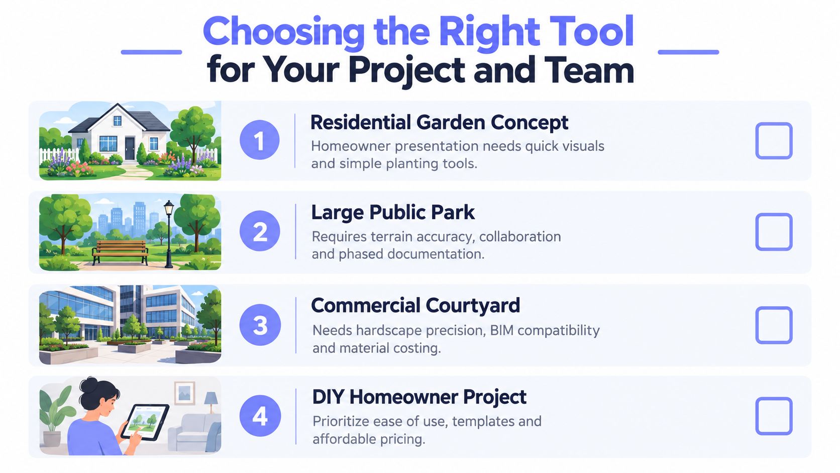
Tool selection becomes easier when the deliverable is stated first. A homeowner presentation, a public park concept, a commercial courtyard package, and a freelancer's proposal all need different balances of speed, accuracy, collaboration, and cost.
| Scenario | Primary need | Practical fit | Main caution |
|---|---|---|---|
| Residential garden concept | Fast approval and clear planting direction | AI concept generation plus a measured plan | A concept render isn't construction documentation |
| Large public realm or park | Terrain accuracy, collaboration, and phased records | CAD or specialist landscape platform with visualization support | Setup and coordination take longer |
| Commercial courtyard | Hardscape precision, material decisions, and costing | CAD or BIM-connected workflow, supported by presentation rendering | Don't let visual polish replace quantities and dimensions |
| Solo freelancer | Fast proposals and low overhead | Cloud rendering paired with a lightweight modeling or CAD tool | Avoid building every client option manually |
Residential work
For homeowner approval, the best tool is often the one that makes the space recognizable. Start with the actual site context, test planting massing and material direction, then move to measured documentation once the client chooses a path. A real-time engine is useful when the discussion depends on walking through the yard, while AI is useful when the client is still comparing broad styles.
Commercial and public projects
Large sites need more than a persuasive image. Teams should prioritize terrain control, georeferenced context, file exchange, phasing, drainage coordination, and a clear record of design assumptions. Visualization still matters, but it should sit on top of a reliable site and documentation workflow rather than carry the project by itself.
Design-build and estimating
A design-build firm needs visuals and quantities to stay aligned. If the software can't support material schedules, dimensions, or a reliable export into the estimating process, the team may create a second manual workflow that erodes the speed gained during presentation.
Sustainability and early site intelligence
Sustainability is where many comparisons remain shallow. Water demand, carbon, biodiversity, shade, soil conditions, and maintenance expectations influence the design before the final render. A useful workflow should let teams capture site context, document assumptions, and explain ecological trade-offs instead of presenting sustainability as a decorative label.
Recent industry coverage describes businesses in outdoor design facing rising expectations around water use, carbon, and biodiversity, alongside demand for earlier material-based estimates and more visual proposals. That pressure supports a decision-software mindset. The tool should help answer not only “What will this look like?” but also “What are we choosing, what does it replace, and what evidence supports the choice?”
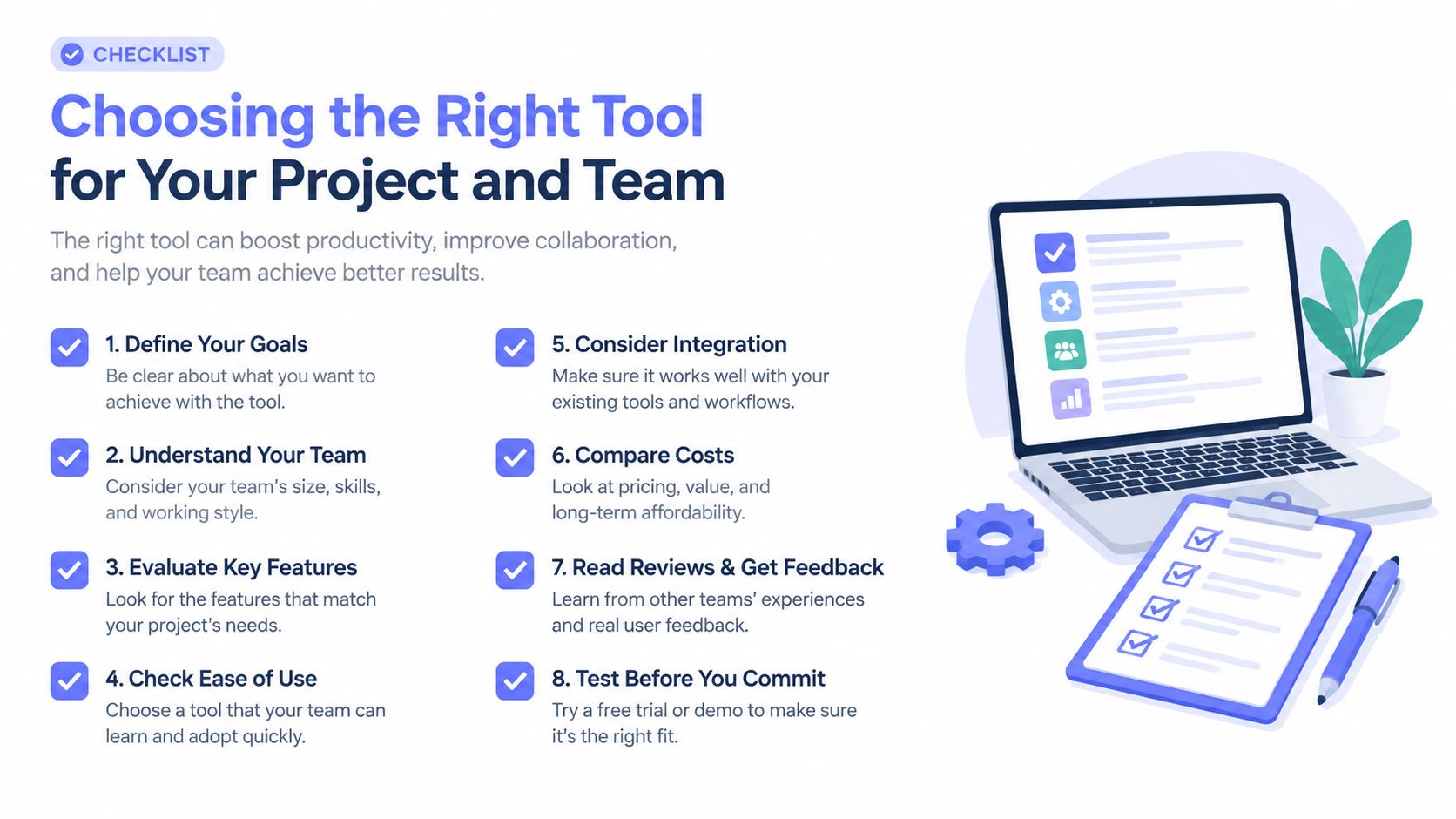
Before committing, run one representative project through the candidate stack. Import the site, build a small hardscape area, place a realistic planting group, produce the client view, and test the export that another team member would need. That trial reveals more than a feature checklist.
Fast Concept Generation Where AI Fits Without Replacing CAD
AI works best at the front of the workflow, where the team is choosing a direction rather than documenting a finished one. A practical sequence looks like this:
- Prepare the input. Use a clean JPEG or PNG floor plan, site sketch, or photo. Remove unnecessary marks and make walls, openings, edges, and key relationships easy to read.
- Generate a first concept. A plan-aware workflow analyzes walls, openings, and spatial relationships, then produces a 3D isometric cutaway visualization after processing the source image, as described in Vizcraft's floor-plan-to-3D workflow.
- Review the design question. Don't ask whether the image is a final survey or construction model. Ask whether the planting structure, circulation, hardscape balance, and material direction are clear enough for a client decision.
- Create controlled variations. Change one major variable at a time, such as planting density, paving character, or garden style. That keeps the review useful instead of turning it into a gallery of unrelated images.
- Refine in traditional software. Once the client approves the direction, transfer the chosen concept into CAD, BIM, a specialist platform, or a measured 3D model for grading, quantities, coordination, and documentation.

Vizcraft offers ISO Mapper for floor-plan isometric views, Interior Design for boards from floor plans, and Exterior Studio for exterior concepts from photos. These images support design discussion; verify dimensions, openings, scale, and construction intent against the source drawings.
This hybrid approach is also covered in the AI workflow for architects. It preserves the division of labor: AI handles rapid communication and option testing, while measured tools handle geometry, compliance, coordination, and construction intent.
You can test the workflow with 2 free credits on signup, no credit card required. If a plan, sketch, or site image is already available, upload it and judge the result against the decision you need to make, not against a promise of replacing your existing software.
Frequently Asked Questions
What's the difference between landscape design software and general 3D modeling tools?
Software for outdoor design usually includes terrain, planting, site objects, hardscape workflows, and presentation features. General modelers such as SketchUp provide flexible geometry, but you'll often assemble outdoor-specific libraries, extensions, and documentation workflows yourself.
Can AI replace site analysis and CAD accuracy?
No. AI can accelerate early visual concepts and help clients compare directions, but it shouldn't replace measured surveys, grading logic, drainage coordination, structural decisions, or construction documentation. Use it before CAD, not instead of CAD.
What exports do landscape clients actually need?
The answer depends on the project. Clients may need presentation images, annotated plans, planting or material schedules, PDFs, walkthroughs, or files that another consultant can open. Confirm the handoff before choosing software, especially when a contractor, architect, engineer, or permitting authority will use the output.
How can I try AI concept generation without committing?
Look for a credit-based workflow rather than a long contract. Vizcraft offers 2 free credits without a credit card, and its paid plans are listed on the pricing page, so you can test a real plan or site image before changing your core production stack.
Use Vizcraft to turn a clean floor plan, sketch, or site image into a client-ready visual after generation completes, then carry the approved direction into your measured design workflow. Start with the 2 free credits, no card required, and test one real outdoor design concept before you decide whether the speed fits your team.