Landscape Architecture Software: A 2026 Buyer's Guide
Compare landscape architecture software by use case, pricing, and workflow. See how 2026 tools handle site modeling, planting, and client visuals.
AutoCAD remains a cornerstone of outdoor and site design workflows, with 73% of respondents rating it extremely important in the 2024 ASLA Digital Technology Professional Practice Network survey. The same survey found that 67% considered Google Earth very important or extremely important, while about two-thirds used Revit or Vectorworks with some consistency, showing that design software for outdoor spaces is no longer a single drafting program. It's a connected stack of CAD, BIM, GIS, visualization, and increasingly lightweight concept tools. (ASLA survey)
The buying decision, then, isn't “Which program is the best?” It's “Which layer of the workflow is failing, and what should handle that job without damaging the editable deliverable?” That distinction matters when you're deciding where an AI render belongs in a BIM-plus-GIS practice.
Table of Contents
- What Landscape Architecture Software Actually Does in 2026
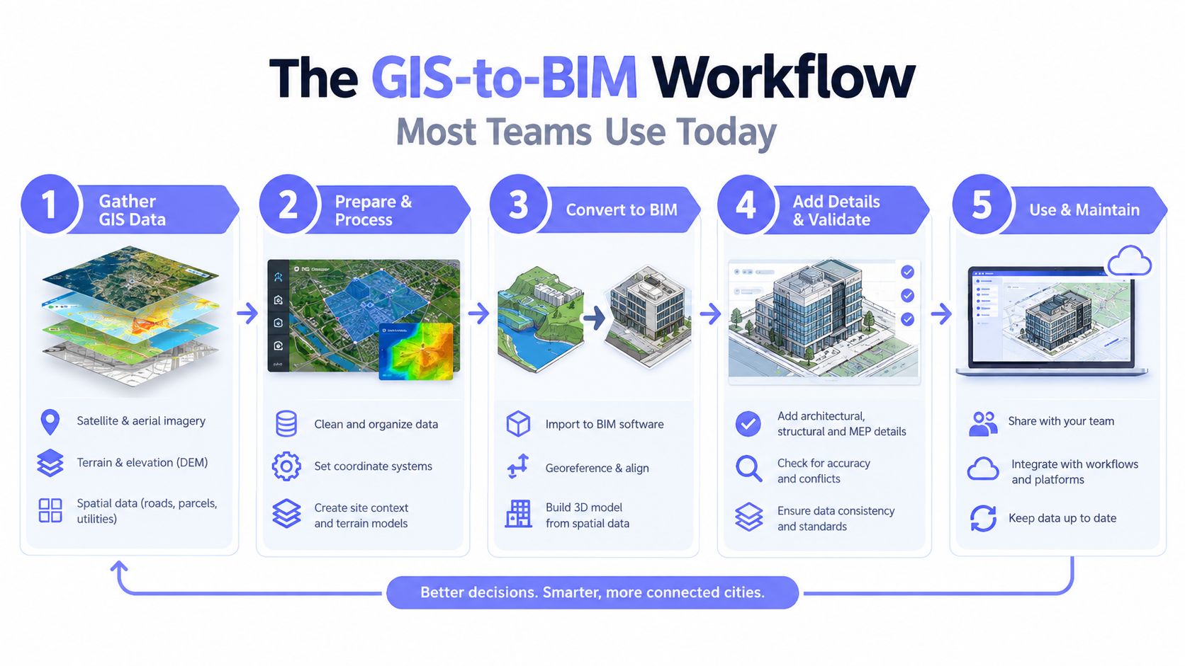
- The GIS-to-BIM Workflow Most Teams Use Today
- Core Job Families Covered by Modern Tools
- Comparing the Tools Landscape Architects Actually Use
- Choosing by Use Case, Not by Brand
- Where AI Rendering Slots Into the Concept Stage
- A Practical Buying Checklist for 2026
- FAQ on Landscape Architecture Software
What Landscape Architecture Software Actually Does in 2026
Exterior space design software is any tool that helps a designer measure, model, specify, document, or visualize an exterior space. That can mean a 2D planting plan, a grading model, a hardscape assembly, a site analysis diagram, or a rendered master plan for a client meeting.
General CAD gives you drafting precision. Outdoor design work asks for more. The software must support terrain, grading, drainage, plant information, hardscape assemblies, site constraints, and sun or shade studies. A program that draws clean lines but cannot manage a surface or connect a plant schedule to a plan may still be useful, but it isn't a complete site-design workflow.
The practical way to assess a stack is to separate the jobs:
- Survey and context: Capture parcel boundaries, contours, soils, hydrology, existing vegetation, and environmental constraints.
- Site modeling: Turn that information into a usable terrain and grading model.
- Design development: Build planting, circulation, walls, paving, structures, and drainage.
- Documentation: Produce coordinated plans, schedules, details, and specifications.
- Presentation: Create still images, walkthroughs, diagrams, and early design options.
Historical adoption helps explain why no single platform owns every layer. GIS entered the field earlier than CAD, while CAD tools developed from the 1960s and became more common in practice during the 1980s. AutoCAD's formal release in 1982 helped establish computer-based drafting as a standard production method. (historical review of digital tools)
Practical rule: Buy the tool that protects the deliverable you're responsible for, then add presentation software around it.
That means an architecture office may need Revit as its coordination spine, Civil 3D or another terrain-focused tool for grading, and a separate renderer for client communication. A small residential practice may need a simpler modeling tool and a fast visual layer. The right stack depends on project scale, file exchanges, staff capability, and how often the client needs to see a change.
For a useful example of how early concepts can support the design conversation without replacing technical drawings, see this guide to landscape design concepts.
The GIS-to-BIM Workflow Most Teams Use Today
An outdoor project usually starts with information that doesn't belong in a render. The surveyor or consultant provides parcel lines, contours, soils, hydrology, flood information, and existing tree data. The designer needs to understand that context before deciding where a path, retaining wall, or planting zone should go.
From site information to a working surface
The first handoff often happens in ArcGIS or QGIS. GIS is useful for organizing georeferenced data and testing site conditions before detailed design begins. A designer can review slope, aspect, watershed behavior, environmental constraints, and canopy coverage before committing to a layout. Broader applications of this type of geospatial reasoning are also discussed in this resource on spatial analysis for real estate markets.
The information then moves into a grading and modeling environment such as Civil 3D, Rhino, or Vectorworks. Here, the site becomes a design surface. You shape the ground plane, test drainage directions, place walls and paths, and begin assessing cut and fill. The transfer sounds simple, but it is at this stage that many projects become unreliable. Units, coordinate systems, datums, and surface types must agree.
Where BIM enters the chain
For multidisciplinary projects, the model may then move into Revit so the grounds team can coordinate with architecture, structural engineering, and MEP consultants. Revit is valuable when the exterior work must align with building levels, entrances, drainage points, underground services, and structural elements. It isn't always the most comfortable place to perform early terrain exploration, so many teams keep specialized site work in another application and exchange the relevant geometry.
The final stages are documentation and visualization. Drawings remain tied to the source model, while a real-time renderer creates a more understandable client view. A site analysis workflow can also sit between GIS and presentation, as explained in this site analysis architecture guide.
Core Job Families Covered by Modern Tools
A useful buying test is to divide the work into four job families. Each family has different accuracy requirements, different libraries, and different failure modes. If a vendor claims to cover everything, ask which of these jobs it handles natively and which ones depend on add-ons or manual work.
| Job Family | Primary Tool Category | Representative Software |
|---|---|---|
| Site modeling | Civil, terrain, and parametric modeling | Civil 3D, Rhino with landscape plug-ins, Vectorworks Landmark |
| Planting plans | Landscape documentation and plant databases | Vectorworks Landmark, DynaSCAPE, Land F/X |
| Hardscape detailing | BIM, architectural modeling, and fast 3D massing | Revit, ArchiCAD, SketchUp |
| Client rendering | Real-time visualization and concept rendering | Lumion, Twinmotion, Enscape, AI image tools |
Site modeling
Terrain and grading are the least forgiving parts of the workflow. Civil 3D is strong when the project depends on surfaces, alignments, profiles, and engineering coordination. Rhino is flexible for complex forms and exploratory geometry, particularly when a practice already works with parametric tools. Vectorworks Landmark provides an outdoors-focused environment that combines site design and documentation.
The trade-off is learning and exchange. A highly flexible modeler can require more setup, while a specialized platform may be easier for standard outdoor site operations but less adaptable for unusual geometry.
Planting plans
Planting design needs more than attractive symbols. The database must support botanical names, quantities, schedules, spacing, and documentation that can survive revision. Vectorworks Landmark, DynaSCAPE, and Land F/X are common examples of tools built around this need, either as dedicated environments for outdoor design or as extensions within AutoCAD or Revit.
A rendering library can suggest the appearance of planting, but it shouldn't be treated as a botanical record. If the deliverable includes a plant schedule, keep that information in the editable production environment.
Hardscape detailing
Walls, paving, decks, stairs, and site structures sit between planting design and architecture. Revit and ArchiCAD make sense when assemblies must coordinate with a building model. SketchUp is often quicker for early massing and client discussion, but detailed documentation may require additional tooling.
Client rendering
The client sees the image, not the data structure behind it. Lumion, Twinmotion, and Enscape provide real-time scene control and are useful when the team needs repeatable camera views, material edits, and walkthroughs. AI tools can produce concept visuals faster, but they don't replace the model that documents dimensions, grades, materials, or quantities.
That's why the stack matters more than the brand. Each tool should own a clear job and pass a clean handoff to the next one.
Comparing the Tools Landscape Architects Actually Use
These tools are often compared as if they were direct substitutes. They aren't. AutoCAD is a drafting and documentation environment, Revit is a BIM coordination platform, Vectorworks Landmark is terrain-oriented production software, SketchUp and Rhino are flexible modelers, and Lumion is primarily a visualization layer.
| Tool | 2D Drafting | Terrain Modeling | Planting Libraries | Hardscape Detailing | Real-time Visuals | Approx. 2026 Cost per Seat |
|---|---|---|---|---|---|---|
| AutoCAD | Excellent precision and DWG exchange | Requires additional workflows | Usually requires Land F/X or another extension | Strong drafting, limited native landscape specialization | Limited without a separate renderer | Subscription, vendor quote |
| Revit | Strong documentation and coordination | Capable, often supplemented for site work | Usually extension or office-standard dependent | Strong BIM assemblies and multidisciplinary coordination | Requires a separate visualization workflow | Subscription, vendor quote |
| Vectorworks Landmark | Strong landscape documentation | Strong landscape and site tools | One of its main strengths | Good landscape-specific detailing | Usually paired with a dedicated renderer | Subscription, vendor quote |
| Lumion | Not a drafting tool | Imports model geometry for visuals | Visual library rather than documentation database | Presentation-focused | Strong real-time presentation | Subscription or license terms vary |
| SketchUp | Basic 2D output with LayOut | Flexible modeling, manual setup | Relies on components and extensions | Fast for early massing and custom forms | Requires a renderer or additional workflow | Subscription, vendor quote |
| Rhino | Precise modeling and drawing support | Strong for complex geometry and analysis workflows | Usually relies on plug-ins or external data | Flexible but setup-heavy | Requires a separate renderer | Subscription or license terms vary |
The key distinction is editable source versus presentation output. AutoCAD, Revit, and Vectorworks contribute directly to technical deliverables. Lumion produces a persuasive view of a model but doesn't replace the model. SketchUp and Rhino can produce useful geometry, though the office must decide how that geometry becomes a coordinated drawing set.
Planting is where general-purpose tools tend to expose their limits. A model may look convincing while still lacking botanical data, quantities, maintenance information, or a dependable schedule. If your firm needs those outputs, judge the planting workflow separately from the render quality.
Estimating deserves its own check as well. A visual model doesn't automatically become a quantity takeoff or proposal. Contractors comparing the production side with estimating workflows may find this overview of Exayard landscaping estimating software useful when mapping design data to commercial decisions.
AI rendering platforms, including Vizcraft, sit beside this table rather than inside it. They can support concept communication, but they shouldn't be mistaken for drafting, grading, planting documentation, or BIM authoring tools.
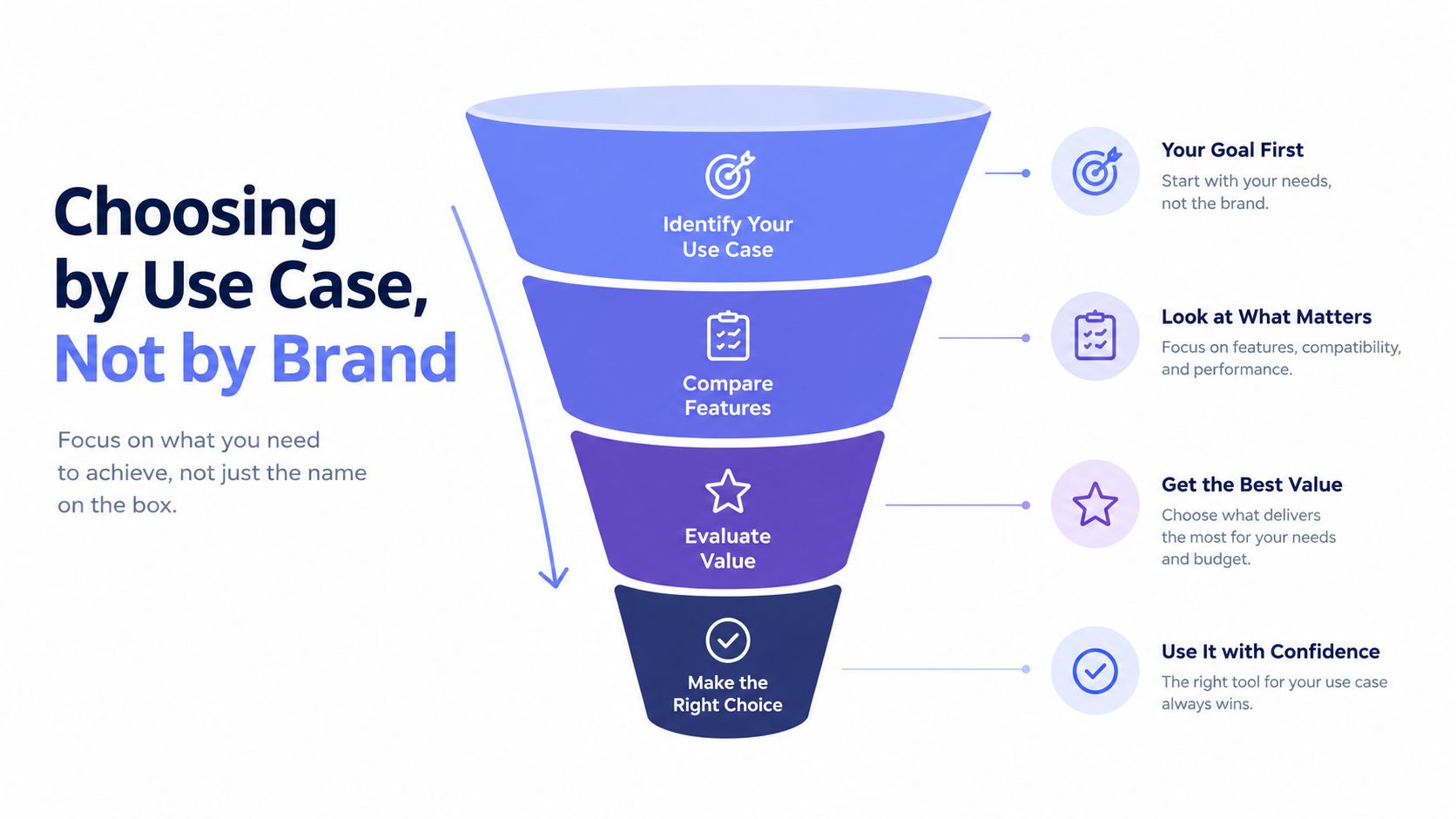
Choosing by Use Case, Not by Brand
A solo designer, an architecture firm, and a contractor can look at the same software list and reach three sensible conclusions. The deciding factor is not prestige. It's the handoff each person must complete at the end of the job.
Solo designer
For a designer handling a small number of projects, the priority is a short path from measured idea to a client-friendly view. Vectorworks Landmark provides more terrain-specific production depth. SketchUp provides flexible modeling and a broad ecosystem. A separate visual layer can handle presentations without forcing every concept change through a heavy production workflow.
Skip tools that require specialist administration if you won't use their coordination features. Plan the first integration around export reliability, especially if a consultant expects DWG, PDF, or another standard format.
Architecture firm
A mixed architecture practice will often favor Revit as the BIM spine, with Civil 3D or another site-focused application supporting grading and terrain. Twinmotion or a comparable renderer can handle the presentation stage. This route favors continuity with the building model, but it asks the team to define ownership of site geometry early.
Don't let the rendering workflow become the only place where design decisions live. The source model must remain authoritative.
Contractor or build-side estimator
Contractors often need fast markups, quantities, client visuals, and a clear path to a proposal. AutoCAD remains useful where DWG exchange dominates. SketchUp can help with custom structures and simple massing. A dedicated renderer may be enough for walkthroughs, while takeoff and estimating remain separate disciplines.
Before adding another application, map the workflow from site visit to estimate. Guidance on how to maximize ROI with construction software can help frame that decision around operational value rather than visual novelty.
The landscape design use cases are a useful way to think about where a fast visual tool belongs, particularly when the client needs to choose between concepts before the technical model is complete.
Where AI Rendering Slots Into the Concept Stage
AI rendering belongs at the point where the team needs to discuss direction but hasn't finished the production model. That is usually between a flat site plan or low-poly massing study and the first serious client review.
The input might be a SketchUp export, a Rhino view, a Vectorworks image, a marked-up sketch, or a site photograph. The output is a visual concept that helps the client react to planting character, paving tone, wall placement, lighting mood, or overall composition. It can reduce the pressure to build every plant, material, and accessory before anyone has agreed on the design direction.
The limitation is just as important as the speed. An AI image doesn't give you a dependable grading surface, a planting schedule, a structural detail, or an editable BIM object. It can sell the idea, but the technical team still has to return to the CAD, BIM, or GIS source file.
A workable handoff
- Export a controlled source view. Use a clean plan, sketch, or model view. Keep the geometry legible and avoid presenting an image that implies more precision than the source contains.
- Generate concept options. Use the image stage to test styles, planting density, material direction, and client preferences.
- Record decisions. Mark which elements were accepted, rejected, or changed. Don't treat the generated image as the drawing set.
- Update the source model. Rebuild the chosen direction in the editable production environment, then document it properly.
Vizcraft's Exterior Studio supports exterior concepts from photos, while ISO Mapper supports plan-based isometric views. These outputs help communicate a direction; dedicated landscape software remains necessary for planting schedules, grading, construction details, and editable CAD files. See current rendering plans for the 2-credit trial and paid allowances.

That credit model makes more sense for occasional concept work than for a team expecting a full documentation platform. The cloud workflow also avoids requiring a local GPU or render farm. For a deeper look at the role of quick visuals in professional workflows, see this guide to AI rendering for architects.
A Practical Buying Checklist for 2026
Treat a new software purchase like a pilot, not a shopping exercise. Pick one real project with a clear output, then test the workflow from imported data to client presentation and final export.
Run the pilot against real files
Use an active project rather than a polished demo file. Confirm that the tool can handle your usual site data, naming conventions, coordinate setup, and consultant exchanges. Test both the successful path and the revision path, because the second or third change is where weak integrations become visible.
Check these items before committing:
- File exchange: Test DWG, IFC, PDF, and any required image exports.
- GIS input: Confirm whether shapefiles, georeferenced imagery, contours, and coordinate systems arrive correctly.
- Plant data: Ask whether plant databases can be synchronized, exported, or maintained without duplicate entry.
- Licensing: Clarify whether the license is per seat, floating, site-wide, or credit-based.
- Cloud access: Check browser support, version history, permissions, and offline limitations.
- Support: Send a real technical question and measure the quality of the answer, not just the response speed.
A cloud renderer and a BIM authoring tool should not be judged by the same criteria. One may be excellent for rapid visual feedback and poor at structured data. The other may preserve coordination and documentation while being slower to use during an early sales conversation.

Finally, ask the contract questions vendors often leave out: Who owns uploaded site context? How long is data retained after cancellation? Can the firm use generated visuals in commercial proposals? Are client files used for service improvement? The answers matter as much as the feature list. This AI landscape design tool guide can help frame the concept-stage questions before you start a pilot.
Frequently Asked Questions
How much does professional landscape architecture software cost?
Costs vary widely by workflow. Entry-level tools may be free or inexpensive, while professional CAD, BIM, site documentation, and visualization stacks usually require paid subscriptions or separate licenses. Credit-based cloud rendering is another model. ISO Mapper lists $19 per month for 25 renders, with one-time packs from $7, according to its published pricing information.
Can one tool handle site modeling, planting, hardscape, and visuals?
Usually not. Site modeling, planting documentation, hardscape detailing, BIM coordination, and client rendering have different requirements. Most professional teams use a stack and define which application owns each deliverable.
How long does a landscape software trial last?
Trial terms vary by vendor. Credit-based tools may let you test a limited number of renders instead of providing unrestricted time. ISO Mapper's published signup offer includes 2 free credits with no credit card required.
What software do architecture firms prefer for landscape work?
Revit, Vectorworks Landmark, AutoCAD, Civil 3D, Rhino, SketchUp, and dedicated renderers all appear in different office workflows. The preferred combination depends on whether the firm prioritizes BIM coordination, grading, planting documentation, complex modeling, or presentation speed.
Does the tool export editable deliverables?
Ask this before asking about render quality. A concept image may help a client choose a direction, but it won't replace an editable site model, planting plan, schedule, grading file, or coordinated construction document.
Use site design tools as a layered system, not a single purchase. If you need fast concept visuals from plans, sketches, or site references, try Vizcraft with 2 free credits and no card required, then return the approved direction to your BIM, CAD, or GIS workflow. Visit Vizcraft to test the concept stage before committing to a larger stack.